Most people visit Angkor Wat and miss Angkor entirely. The famous temple is one structure in a ruined civilization that once stretched across more than a thousand square kilometers of Cambodian forest. Over the following six hundred years, successive rulers transformed this region into one of the most ambitious urban landscapes the pre-industrial world had ever seen, a sprawling network of temples, reservoirs, canals, and residential quarters that at its peak supported a population estimated at nearly one million people.
Explore Angkor
Discover Angkor through photos that tell the story.
Find out how well you know Angkor.
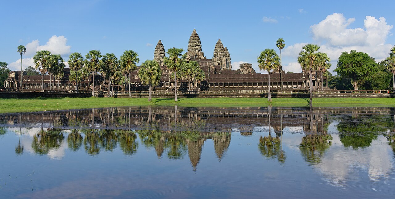
The crown jewel of the complex is Angkor Wat, built during the reign of Suryavarman II in the first half of the twelfth century. Originally dedicated to the Hindu god Vishnu, the temple is an architectural representation of Mount Meru, the mythological home of the gods in Hindu cosmology. Its five lotus-shaped towers rise sixty-five meters above the surrounding plain, and its outer walls enclose an area of roughly two hundred hectares, making it the largest religious monument on Earth. The temple's galleries contain nearly two thousand square meters of bas-relief carvings depicting scenes from Hindu epics, historical battles, and the daily life of the Khmer court. These reliefs are carved with such precision that individual figures display distinct facial expressions, textile patterns, and even hairstyles that scholars use to date and identify specific periods of Khmer artistic development. Remarkably, the entire structure was built without mortar; its sandstone blocks, quarried from the Kulen Mountains some forty kilometers away, are held together purely by gravity and the skill of their shaping.
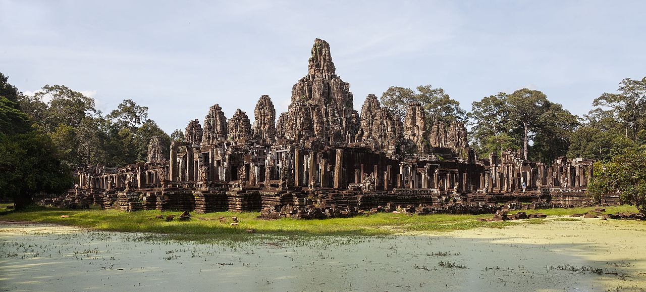
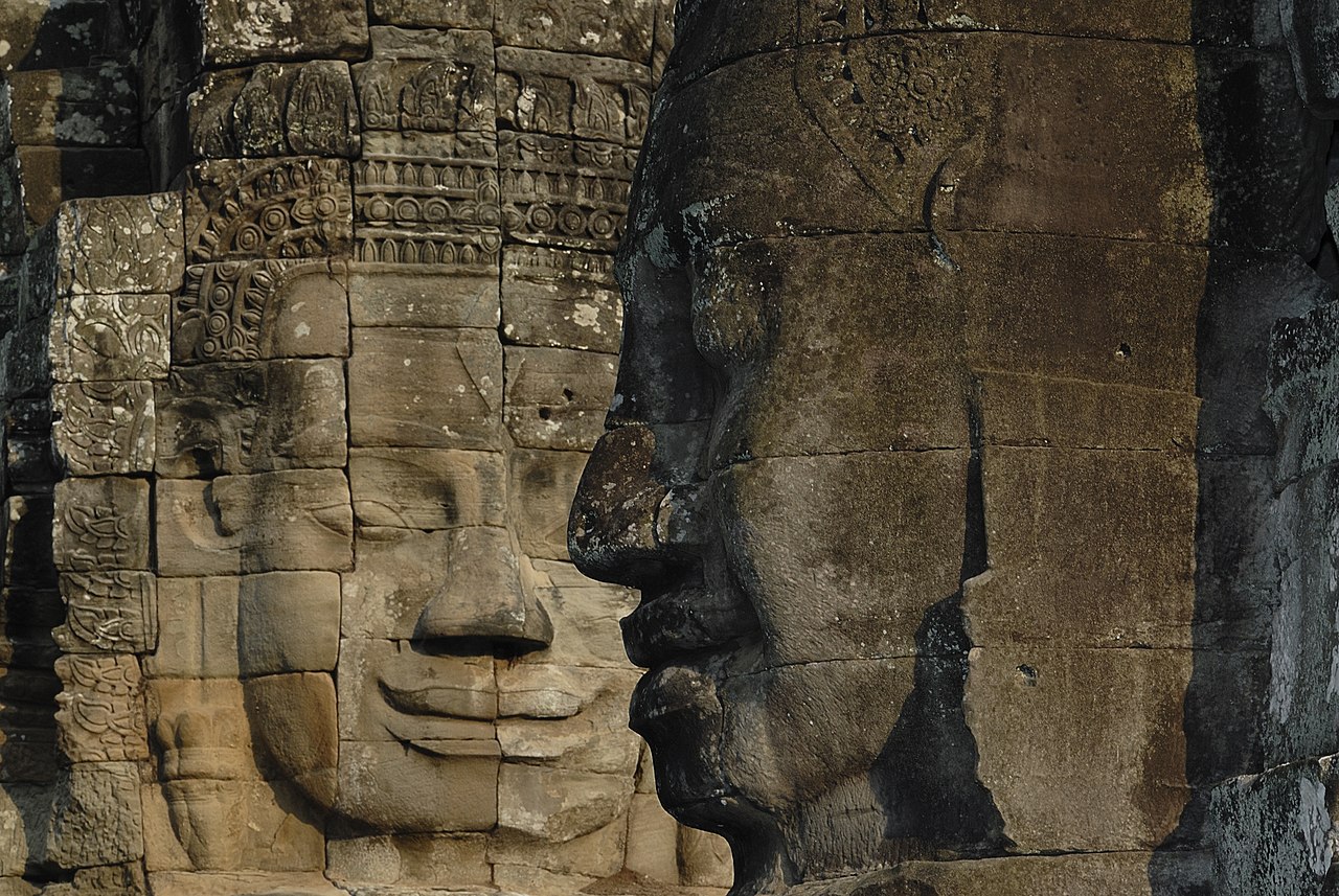
A few kilometers north of Angkor Wat lies Angkor Thom, the walled city that served as the empire's last great capital. At its center stands the Bayon, the state temple of King Jayavarman VII, who came to power in 1181 after driving out Cham invaders. The Bayon is unlike any other temple in the complex. Its fifty-four towers are carved with over two hundred massive stone faces whose serene, slightly smiling expressions have provoked centuries of scholarly debate about whether they represent the king himself, the bodhisattva Avalokiteshvara, or some deliberate fusion of the two. Jayavarman VII was the first Khmer ruler to embrace Mahayana Buddhism as a state religion, and his building campaign was staggering in its scope. In addition to the Bayon, he constructed the monastery of Ta Prohm, dedicated to his mother, and Preah Khan, dedicated to his father, along with hospitals, rest houses, and an extensive road network that linked the empire's provinces to the capital.
Ta Prohm has become one of Angkor's most photographed sites, largely because conservation teams chose to leave much of it in the state in which it was found. Enormous silk-cotton and strangler fig trees have fused with the temple's sandstone walls, their roots cascading over doorways and splitting galleries apart in a spectacle that blurs the line between ruin and living forest. The temple was originally home to more than twelve thousand people, including over six hundred dancers, and its upkeep required contributions from more than three thousand villages across the empire. This single fact hints at the immense economic machinery that sustained Angkor at its height. The civilization's prosperity rested on a sophisticated hydraulic system, the baray, a series of enormous reservoirs and canals that captured monsoon rainfall and redistributed it during the dry season, enabling multiple rice harvests per year. Recent lidar surveys have revealed that this water management network extended far beyond what was previously known, covering an area that dwarfs the visible temple zone and suggesting a level of environmental engineering that rivaled anything in the ancient world.
The decline of Angkor was not the sudden catastrophe that popular imagination often suggests. By the fifteenth century, shifts in trade routes toward coastal ports, prolonged droughts interspersed with catastrophic floods, and internal political fragmentation gradually drew the center of Khmer power southward to Phnom Penh. The temples were never truly abandoned, as Buddhist monks continued to maintain shrines at Angkor Wat, but the vast urban infrastructure fell into disuse and the forest reclaimed its territory. French naturalist Henri Mouhot brought Angkor to Western attention in the 1860s, though local populations had always known the temples were there. His breathless accounts launched a wave of archaeological interest that continues to this day.
Visiting Angkor today is an experience that unfolds across multiple days and moods. Sunrise at Angkor Wat, with the towers silhouetted against bands of orange and violet, draws thousands of visitors each morning, yet the complex is so vast that solitude is always possible for those willing to explore beyond the main circuit. The carved lintels of Banteay Srei reveal a finesse that earned it the nickname "citadel of women" for the delicacy of its ornamentation. The jungle paths around Beng Mealea offer a sense of discovery that echoes the experience of nineteenth-century explorers. Throughout the complex, Cambodian families picnic in temple courtyards, monks in saffron robes offer blessings, and the sound of cicadas fills galleries where Khmer dancers once performed for kings. Angkor is not a museum frozen in the past but a living landscape where eight centuries of history coexist with the rhythms of contemporary Cambodian life.